Discovering the location of an ancestor’s land is always exciting. Once the approximate location has been determined, we can visit the land and imagine the work that went into settling it. Land grants, patents, and deeds are all land records that can reveal the location.
Because my paternal lines are out of the South and I grew up in the West, I haven’t had the opportunity to visit the Southern states, much less the actual land. On my recent (and first) trip to South Carolina, I visited the South Carolina Department of Archives and History (SCDAH) in Columbia, speaking at the annual workshop for the SC Genealogical Society. Hoping to do some onsite research, I revisited details about my 4th great-grandfather, William Keaton, who resided in Pendleton District, South Carolina, which became Anderson District in 1826.
-

- South Carolina Archives at Columbia
-

- Cheri Passey and Diana
-
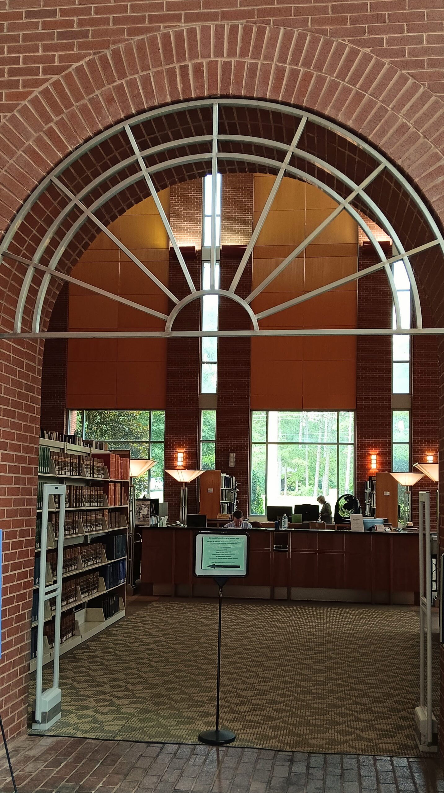
- Interior of the SC Archives
Understanding South Carolina Jurisdictions
William first appears in the records in a land grant in Pendleton County, 96 District, in 1792. Jurisdiction and locality are confusing for this era in South Carolina. The state had overarching districts that included several counties until 1800 when the districts were abolished. In 1826, Pendleton County was dissolved and became Anderson, so records are searched under Anderson County. Having the exact location of William Keaton’s land is very helpful when it comes to discovering which jurisdiction his records might fall in.
The map below shows South Carolina Districts and Counties from 1791-1799.1 Marked with a red star is the approximate location of William Keaton’s land, as described in the land grant.2
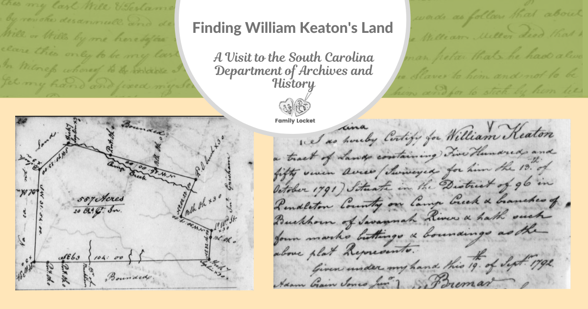
William Keaton, 577 acres, surveyed for him the 13th of October situate in the District of Ninety Six in Pendleton County on Camp Creek and branches of Buckhorn waters of Savannah River, bounded by lines running NW & NE by John Grishams land all other sides by old surveys & vacant.
Signed Charles Pinckney, Governor 1 Oct 1792
Certified by Peter Breman Surveyor General 19 Sept 1792
The grant states, “Pendleton County, 96 District,” but the map below shows the land to be on the southern border of Pendleton County, which was in the Washington District. Perhaps the surveyor incorrectly identified the district or the district boundaries were difficult to determine when the land was located on the border.
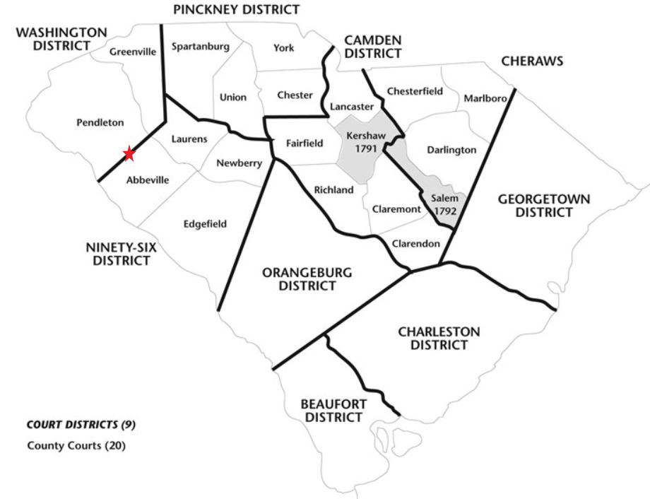
South Carolina Districts and Counties, 1791 – 1799
Value of Plat Maps
The 557-acre grant came with a land plat map that shows the boundaries, neighbor John Grisham on the right, and the location of Camp and Buckhorn Creeks. 3
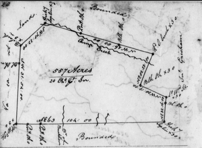
1791 William Keaton Plat Map, Pendleton County, South Carolina
Under the plat map, the following is written:
I Certify for William Keaton a tract of land containing Five Hundred and fifty seven acres (surveyed for him the 13th of October 1791) situate in the District of 96 in Pendleton county on Camp Creek & branches of Buckhorn of Savannah River & hath such buttings and bounding as the above plat represents.
Given under my hand this 19th of Sept. 1792.
Adam Jones Junr. Breman
Deputy Surveyor Surveyor General
What is the value of seeking out the plat map for a parcel of land? Seeing Camp Creek and Buckhorn Creek locations on the plat gives a good estimation of where the land plat lay and could give clues to modern-day locations. With the help of the archivist, I located a historical map of Pendleton County, and we found the two creeks.4 William Keaton’s land would have been somewhere near the red star.
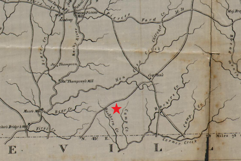
Pendleton District, South Carolina, 1825
History of South Carolina Land Grants
The SSCDAH website gives an excellent summary of the process by which the state granted land after the Revolution. When the British evacuated South Carolina in 1783, the state was left in need of funding to rebuild after many years of war. Like other states, unclaimed land was abundant, and by selling it, the state government could not only settle the state’s debts but refill its coffers.
In 1784, the state passed “An Act for Establishing the Mode and Conditions of Surveying and Granting the Vacant Lands Within this State.” Initially, a grantee was to pay $10 per hundred acres, but in 1791, the price was dropped to cover just the filing and surveying fees. William Keaton took advantage of this law and had the 557 acres on the southern edge of Pendleton District surveyed. With access to two creeks, this would have been an excellent location for his land.
Keeping the Records
As genealogists, we are concerned with records, and understanding how they were created and stored helps us locate them and use them. Under the 1784 law, a Commissioner of Location was appointed for each district. When an individual located land they wanted to survey, they would first obtain a survey warrant from the commissioner, then have the land surveyed by the Deputy Surveyor. He would create a scaled drawing or plat map using metes and bounds. This form of land measurement used degrees and landmarks. In William Keaton’s plat, the landmarks were the two creeks, and the drawing shows the various calculations used to measure out the 557 acres.
The Commissioner of Location recorded the surveyed plat in his plat book and sent the original plat to the State Surveyor General in Charleston. He also recorded it in a plat book and then sent it to the Secretary of State, who prepared the land grant for the Governor to sign. Another copy of the plat was made and attached to the grant which the grantee received.
The plat and grant given to the grantee may have been passed down through the family but often was lost. Because of the copies kept in the Surveyor General and Secretary of State’s office, we have this valuable resource available.
The SCDAH details some limitations to the plats.5
A few of the plats are from before the Revolution and represent lands that had been platted but not granted when the war broke out in 1775. Some others don’t really include ungranted lands, but are for grants designed to clear up murky or defective titles. Plats often overlap or have gaps between them, so you should not expect that they will fit together exactly like a puzzle would. These plats are not part of an overall grid platting scheme like you may see in states farther west. Each plat was drawn independently, using markers like trees, stumps, and rocks as boundaries.
Finding and Using the Records
The SCDAH has digitized the records, and they are available via the Online Records Index. The search engine allows you to search by name, location, or date. When you locate the record for your ancestor, be sure to download the image to your own files and create an entry in your timeline or research log with the citation and record details.
Because I was reasonably sure this land grant applied to my ancestor, I added it to the timeline for William Keaton. If I were unsure, I would have put it in my research log with a note to discover if there was another person of the same name that the grant could have been for. A good clue to connect William Keaton to the land was the neighbor, John Gresham. Researching William had found his wife to be Katy Gresham, who had a brother named John. Further research can now explore John and solidify this connection. Finding the land plat map and location of William Keaton’s land was another piece of the puzzle we’re putting together of his life and family. Someday I hope to visit the land and stand where my Keaton ancestors lived.
Best of luck in all your genealogical endeavors!
Sources
- South Carolina Dept of Archives and History, “Districts and Counties, 1791-1799” (https://www.archivesindex.sc.gov/guide/countyrecords/1791.htm : accessed 16 July 2023).
- South Carolina, Land Grants 1784-1882, William Keaton, 1792, Pendleton County, vol. 31, p. 193; digital image, FamilySearch (https://www.familysearch.org/ark:/61903/3:1:3Q9M-CSKW-MSLM : accessed 12 July 2023).
- South Carolina Dept of Archives and History, William Keaton Land Plat, 1792, 557 acres, digital image, (https://www.archivesindex.sc.gov/ : accessed 12 July 2023); State Plat Books (Charleston Series) (S213190), Archives ID: Series: S213190 Volume: 0031 Page: 00020 Item: 000.
- Robert Mills, “Pendleton District, South Carolina, 1825, Library of Congress (https://www.loc.gov/resource/g3913a.cws00151/ : accessed 16 July 2023).
- Wade Dorsey, “State Plats for Land Grants 1784-1868 Now Available Online,” The Silver Crescent Standard, SC.GOV(https://scdah.sc.gov/news/2021-06/state-plats-land-grants-1784-1868-now-available-online : accessed 16 July 2023).


2 Comments
Leave your reply.